The Gambia Joins the IHO: Strengthening Hydrographic Capacity in West Africa
Date de publication: 13/05/2025 - 09:37The International Hydrographic Organization (IHO) proudly welcomes the Republic of The Gambia as its newest Member State, marking a significant milestone for both the Organization and the West African region. With this accession, the global hydrographic community continues to grow in Africa, underscoring the increasing recognition of the importance of hydrography for safe navigation but also coastal zone management, tourism, UNCLOS obligations and more.
A Strategic Maritime Nation
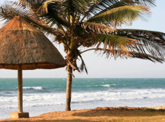
Located on the Atlantic coast of West Africa, The Gambia boasts 80 km of coastline and a navigable river stretching over 400 km inland. The Port of Banjul, situated at the mouth of the River Gambia, serves as the country’s main maritime gateway, handling over 80% of the nation’s trade, with over 2.7 million tons of cargo traffic recorded in 2024. Major global shipping companies operate regular services to the port.
Yet, despite the critical role of maritime transport in The Gambia’s economy, the country has faced significant challenges in the field of hydrography. Many of its river and coastal areas remain uncharted or have not been surveyed since the 1940s, limiting safe navigation, port efficiency, and the ability to manage its marine environment effectively.

A Strategic Step Forward
Speaking on this important milestone, the Honourable Minister of Transport, Works and Infrastructure of The Gambia, Ebrima Sillah stated:
“Joining the International Hydrographic Organization is not merely an affirmation of our commitment to global maritime standards; it is a strategic step towards enhancing our navigational safety, fostering economic development, and protecting our precious marine resources. By aligning with international best practices in hydrography, The Gambia positions itself as a responsible maritime player, ensuring safer waters for our shipping industry and sustainable practices for future generations."
Unlocking New Opportunities
As an IHO Member State, The Gambia now stands to benefit from increased international cooperation, technical support, and access to global best practices in several key areas including:
Tourism and Recreational Boating
Tourism is a vital and growing sector in The Gambia. The country’s coastline and inland waterways—particularly the River Gambia—offer a wealth of opportunities for eco-tourism, river cruises, birdwatching, and cultural excursions including to UNESCO World Heritage sites. Cruise lines and recreational boaters have increasingly called at Banjul Port, with vessels also venturing inland to explore the natural and historical treasures along the river.
However, many areas remain uncharted, limiting safe access to scenic and remote destinations. Accurate nautical charts, derived from modern hydrographic surveys, are essential to improving navigation safety and unlocking the full potential of maritime tourism.
For many nations, tourism represents a significant source of revenue and employment.
Safety of Navigation
The Gambia Ports Authority is the nation’s hub for international maritime trade and all sea borne traffic to The Gambia passes through Banjul Port. The River Gambia, and inland and coastal waterways constitute vital trade routes for the country. Up-to-date nautical charts and reliable hydrographic data are essential to ensure the safety of navigation, especially as traffic continues to grow and diversify.
Coastal Zone Management
Maintenance of port access channels and berths, as well as projects such as the development of a new deep-sea port along the Atlantic Coast, require dredging which relies heavily on accurate hydrographic information. Such data will also support national initiatives on land reclamation and infrastructure development, all aligned with The Gambia’s National Transport Policy.
Furthermore, hydrographic surveys will provide the necessary data for projects under conventions to which The Gambia is a party, such as the Abidjan Convention.
Marine Resource Exploration
Hydrographic surveys can play a role in identifying undersea hydrocarbon seeps and supporting offshore energy exploration. As an IHO Member State, the Gambia will benefit from the full breadth of capacity-building initiatives and access to a network of experts. The Gambia aims to strengthen its ability to conduct multi-beam surveys and interpret seabed geology, unlocking potential for future resource development.
Environmental Protection
Hydrography is one of the disciplines which can feed information as part of the assessment of environmental impacts related to dredging and construction, and for the management of marine sanctuaries and protected areas. Data from hydrographic surveys feed into Geographic Information Systems (GIS) used by environmental agencies to guide policy and regulatory decisions.
UNCLOS & the Extended Continental Shelf
Parties to the United Nations Convention on the Law of the Sea (UNCLOS) can under certain circumstances access the natural resources up to the outer limits of their continental shelf—claims that require robust hydrographic and geological data to be substantiated. With reinforced capacity in hydrography, IHO Member States like The Gambia can take benefit from natural resources available to them.

Looking Ahead
“The hydrographic responsibilities for a developing coastal state like The Gambia are not easily achievable due to economic reasons, lack of adequate capacity in terms of trained personnel and hydrographic and/or survey equipment. However, through technical cooperation established within the framework of international organizations such as IHO, IMO or UN, or by bilateral arrangements between states, such challenges can be overcome. The IHO, being an inter-governmental consultative organization that sets standards for hydrographic surveys and chart production, offers technical advice and capacity building to its member states to achieve their hydrographic responsibilities. All the above served as significant motivations for the Gambia to become a member state of IHO.”
- Captain Kulay Manneh, Harbour Master Banjul Port.
The Road to Membership
The Gambia’s journey toward IHO membership has been shaped by over two decades of engagement. Following Technical Visit by the IHO in 2003, 2017 and then 2019, national authorities identified the importance of establishing a national hydrographic service. These missions helped raise awareness among stakeholders, outline capacity gaps, and recommend practical steps for building national capability in hydrography.
Membership in the IHO offers access to training, technical expertise, and a global network of hydrographic professionals. It also affirms The Gambia’s commitment to enhancing maritime safety and advancing blue economy opportunities. A warm welcome to The Gambia!


Share this page: