Programme de Cours
![]()
This training course is expected to be delivered primary at the UK Hydrographic Office (UKHO) in Taunton, UK, by the UKHO and other institutions. The course content has been updated regularly to reflect new technologies. The current standard programme outline for training courses from 2026 onwards is expected to include the following:
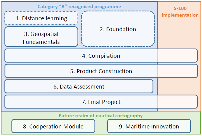
- Distance Learning Module
- Self-paced learning to introduce the basic elements equivalent to 1 week of study.
- Textbooks will be distributed to students approximately six weeks prior to the in-person course commencement will be marked in advance.
- Foundation Module – 4 weeks (including 2 weeks remotely).
- To introduce the underlying principles of marine cartography, covering charting and geospatial fundamentals and database management.
- The foundational content for the first two weeks of this module will be delivered through supervised remote learning.
- Geospatial Fundamentals Module – 2 weeks.
- To cover the fundamentals of geospatial information, including the IHO S-57 data transfer standard, the practical aspects of S-57 Composer software and data management in geospatial databases.
- Compilation Module – 3 weeks.
- Practical training in creating a geospatial database using a primary dataset, covering the bathymetric elements, coastlines, scheduling, field exercises, and metadata.
- To introduce the concepts of IHO S-100 production, IHO S-101 editing and S-57 to S-101 conversion.
- Product Construction Module – 3 weeks.
- To produce ENC and paper charts from the geospatial database, including the quality assurance and publication processes.
- To provide an overview of S-101 product.
- Data Assessment Module – 4 weeks.
- Practical training in critical decision-making and the implementation of the safety information, such as Notice to Mariners, new or revised editions, to support the maintenance of nautical chart products and fulfil the responsibilities of the Hydrographic Offices.
- Final Project – 4 weeks.
- Comprehensive exercise for each student involving the creation and maintenance of S-57 and S-101 products.
- In the Final Project, students will also review and evaluate the entire course, identifying their key lessons learnt.
- Cooperation Module – 1 week
- To introduce the latest integrated data management framework for ocean governance, based on the Maritime Spatial Data Infrastructure (MSDI) and the S-100 data models.
- To introduce the latest seabed mapping technologies, highlight the significant and multiple demands for seabed data and present the Nippon Foundation-GEBCO Seabed 2030 project.
- Maritime Innovation Module – 1 week
- To introduce the new technological components for maritime safety, such as cyber security and AI for Autonomous Ships.
- To introduce the practical applications of maritime data and their specific benefits for ocean environment management, conservation and restoration, with focus on the broader need for ocean knowledge.


Share this page: