Course Programme
The training course is expected to be delivered by the UKHO in Taunton, UK and other institutions.
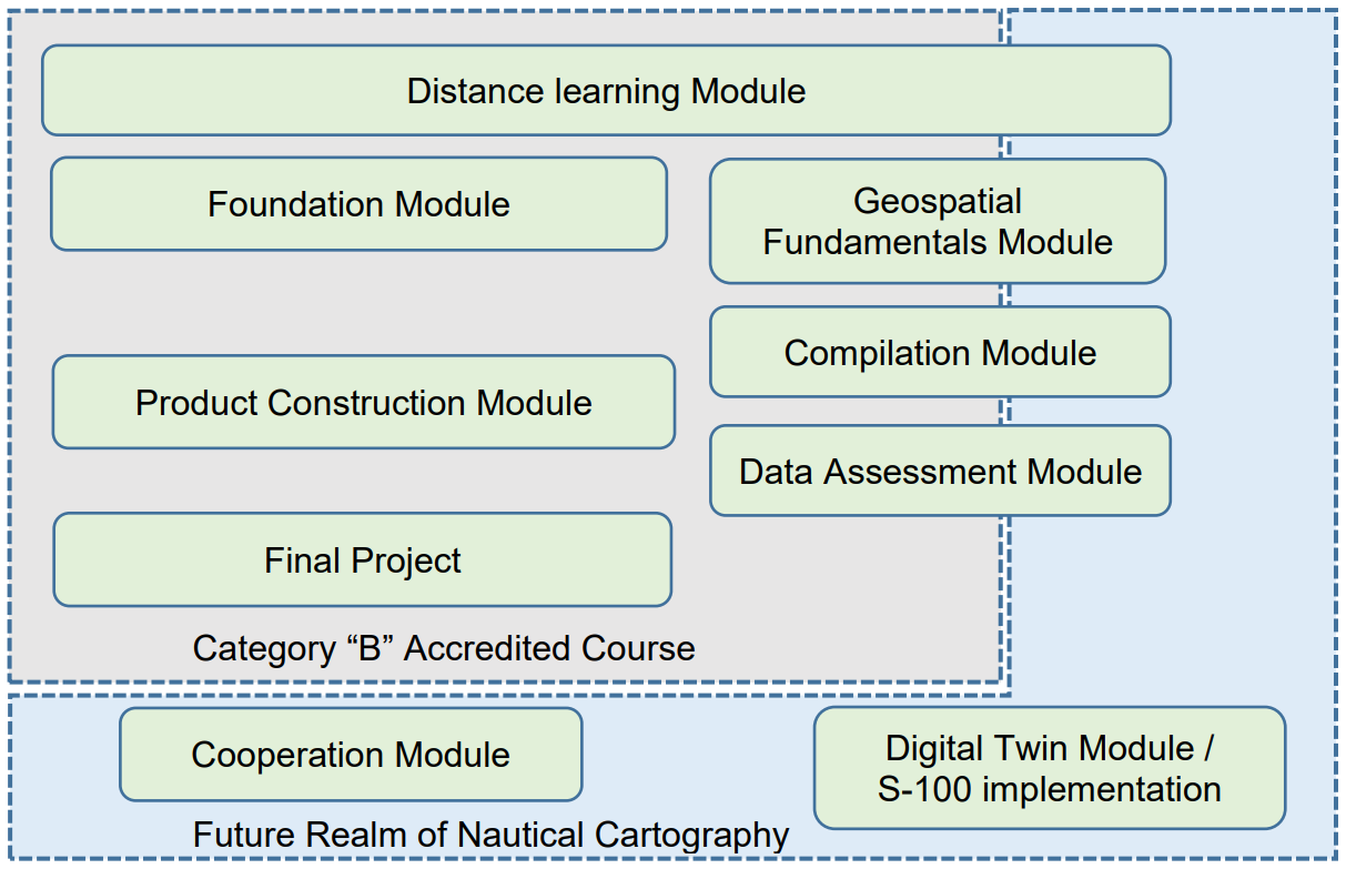
The typical programme outline for this training course is expected to include the following:

- Distance learning Module
- 1 week for the UKHO course. A textbook (paper/ digital) is sent to students 6 weeks prior to cover the basic elements. Assessment submitted by students and marked ahead of in person course commencement.
- 1 year license for further E-learning material on Udemy.
- Foundation Module (typically 4 weeks)
- Cartographic basics covering the underlying details of nautical cartography.
- Focuses on the need for Hydrographic Governance, the IHO Standards for Data collection and development of special purpose charting.
- Geospatial Fundamentals Module (typically 2 weeks)
- Understanding the IHO S-57 Transfer Standard as well as practical aspects of S-57 Composer software and appropriate data management regarding geospatial database.
- Compilation Module (typically 3 weeks)
- Practical module regarding compilation into a geospatial database (bathymetry element, coastline, scheduling, field exercise and meta-data) in compliance with IHO S-57 and S-58 using CARIS software.
- Product Construction Module (typically 3 weeks)
- Production of an ENC / Paper Chart (from data capturing to quality assurance and publication process).
- Introduction of the future standard such as S-100.
- Data Assessment Module (typically 4 weeks)
- Decision making and processing of new information using software and traditional checking processes to fulfil the responsibility of Hydrographic Offices (Notice to Mariners, New Edition and Maintenance).
- Final Project (typically 4 weeks)
- Comprehensive exercise by students including course review, evaluations and lessons learned sessions.
- Cooperation Module (typically 1 week)
- Integrated data management for Maritime Spatial Data Infrastructure (MSDI) for the better ocean governance.
- Introduction of ocean mapping, from data collection to product development, to the trainees, and to familiarize them with the multiple users and uses for seafloor maps.
- Digital Twin Module (typically 1 week)
- Digital twins, S-100 implementation and the link with MSDI, and their potential to be used by autonomous vessels as a 3D world view for navigation purposes bringing efficiency, safety and environmental benefits to the shipping sector.


Share this page: