Search results
There are 516 results for “fc coins 26 Besuche die Website Buyfc26coins.com. Billig und seriös..cwku” in All
CSBWG10 (March 2021)
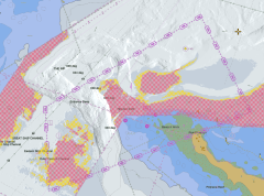
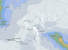
10th CSBWG Meeting 30 March-1 April 2021, Remote VTC Meeting Post Meeting Documents: [Report] [Photo] Last updated: 29 April 2021 Document No Document Title Date CSBWG10-Invitation Letter Letter of Invitation v1.0 CSBWG10-Annex A Registration Form (pdf Version) CSBWG10-Annex A Registration Form (Word Version) CSBWG10-Annex B Logistic Information CSBWG10-Document Template Document Template (Word version) 8 February 2021 CSBWG10-1.3-Agenda CSBWG10 Draft Agenda v8.0 26 March 2021 CSBWG10-1.4-Meeting Report CSBWG9 Meeting Report 30 March 2021 CSBWG10-1.4-IRCC12 Relevant outcomes of IRCC12 9 February 2021 CSBWG10-1.4-Action List List of Actions - CSBWG9 - updated 30 March 2021 30 March 2021 CSBWG10-1.4.1-Action List Chair comments CSBWG10-Day1 Read ahead documents 17 March 2021 CSBWG10-Day2 Read ahead documents 26 March 2021 CSBWG10-3.1 China CSB activities and proposal for International efforts 26 March 2021 CSBWG10-4.1.2 Regional Hydrographic Commission meetings 8 February 2021 CSBWG10-4.1.3 IHO CLs Generic Responses 4 March 2021 CSBWG10-4.1.4 Data Gathering Terminology 4 February 2021 CSBWG10-5.1 B-12 (IHO Guidance on Crowdsourced Bathymetry) Edition 2.0.3 8 February 2021 CSBWG10-5.1.1 Resolution 2/2007, as amended, dated 07.10.2020 30 March 2021 CSBWG10-5.2 Draft proposed amendments to B-12 12 March 2021 CSBWG10-5.2.1 Draft proposed amendments to B12 - Trusted Node 26 March 2021 CSBWG10-5.2.2 Proposal on the development of Chinese version of B-12 26 March 2021 CSBWG10-6.1 CSBWG10-6.2 ToRs and RoPs 8 February 2021 CSBWG10-6.5 Proposed draft agenda for CSBWG11 v1.0 30 March 2021 CSBWG10-Presentations Presentations.zip 1 April 2021 CSBWG10-Participants CSBWG10 List of Participants - Final 2 April 2021
Alumni Seminars
The alumni network of the JCBP, CHART and GEOMAC project has been expanding to a large community of nautical cartographer in the world. To strengthen the tie among alumni and to discuss various issues which are shared with world cartographers, the IHO and Nippon Foundation have hosted the Alumni Seminars.
IHO Technical Standard(old)
Introduction The IHO technical Working Groups, Project Teams and Correspondence Groups conduct the work under the guidance of the HYDROGRAPHIC SERVICES AND STANDARDS COMMITTEE (HSSC). Please see the HSSC page for additional information on the technical standards development activities of the Organization.
MEETINGS AND CONFERENCES AFTER 2024
List of ABLOS Meetings and Conferences Note: To access the meeting page, you'll need an IHO Portal account. If you don't have one yet, don't worry! Creating an account is easy. Simply follow the instruction provided at the link here to set up your account and gain access to the meeting page. Click the IHO Portal to get started ABLOS Meetings and Conferences Year Title Venue Date Remarks 2025 32nd ABLOS Business Meeting Doha, Qatar 6 and 9 October 2025 IHO Portal 2025 12th IHO-IAG Advisory Board on the Law of the Sea (ABLOS) Conference PROGRAMME (For more information and to register, please consult the ABLOS Website) Doha, Qatar 7 and 8 October 2025 ABLOS Website
IBSC47 (2024)
IBSC47 Meeting Hamburg, Germany 15 - 26 April 2024
IBSC Recognized Programmes and Schemes
The IHO keeps a list of all institutions or professional bodies recognized by the FIG-IHO-ICA IBSC against the Standards of Competence. Standards indicate the minimum degree of knowledge considered necessary for hydrographic surveyors and nautical cartographers to meet national and international hydrographic and charting requirements and the diverse needs of industry.
SCOPE4
Southampton, United Kingdom (National Oceanography Centre) Hybrid Meeting 26 October 2022 13:45 - 15:15 (UTC +1)
What is Hydrography ?
Hydrography involves measuring the depth of the water and fixing the position of all the navigational hazards that lie on the seafloor, such as wrecks and rocks. This is done mainly with specialised ships and boats operating echo sounders and sonars, but also using survey aircraft fitted with lasers. Useful information can also be derived sometimes from satellite observations. Hydrography also involves measuring the tide and the currents. The most well-known application of hydrographic information is for making the nautical charts that all mariners use for navigation. Hydrographic information is required for the safe, efficient and sustainable conduct of every human activity that takes place in, on or under the sea.
Smart Navigation Moves Closer to Reality: Completion of Phase 1 of the S-100 Implementation
With the operational release of standards S-124 Navigational Warnings and S-128 Catalogue of Nautical Products, Phase 1 of S-100 Standards implementation has now been completed, marking a major step in the modernisation of navigation. Products and services using these specifications can be updated in near real-time, directly supporting the enhancement of navigational safety and facilitating on-board data management. Data services conforming to these standards are now ready for production and integration into navigation systems such as the S-100 ECDIS.