The S-100 framework is now operational
Published: 10/03/2026 - 13:22A significant step in the implementation of the S-100 ecosystem was officially achieved in January 2026, when the Phase 1 S-100 product specifications entered into force. Stakeholders can now access and use the operational version of these specifications in real-world environments.
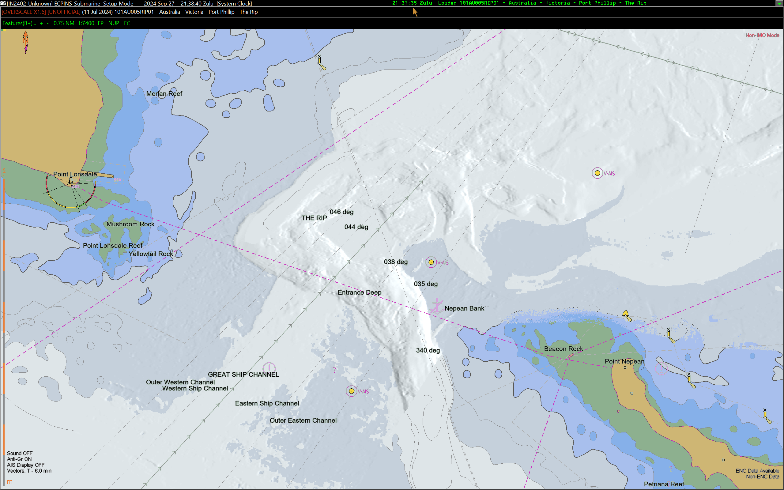
Image shows S-102 Bathymetric Surface over S-101 Electronic Navigational Charts (ENCs).
Image copyright: OSI Maritime Systems
By enabling data interoperability within a single integrated system, S-100 connects the data layers that mariners and ocean data users rely on. From port logistics to real-time navigation, as well as applications in environmental monitoring, S-100 will facilitate safer arrivals and manoeuvres, a more efficient traffic flow, a more sustainable maritime travel, and seamless port operations.
One major difference with the S-57 standard currently in use is that systems using S-100 data will be able to be updated in near-real time, reflecting the situation, elements and conditions surrounding a vessel, giving mariners the most up-to-date information possible. S-100 based data services also allow for a greater situational awareness and a larger manoeuvrable navigational area, making seafarers better equipped for emergencies or abrupt changes in circumstances.
What happens now?
IHO Member States and stakeholders can now begin to produce, test, and use the operational versions of the following S-100 product specifications:
- S-101: Electronic Navigational Charts (ENCs)
- S-102: Bathymetric Surface
- S-104: Water Level Information
- S-111: Surface Currents
- S-124: Navigational Warnings
- S-128: Catalogue of Nautical Products
- S-129: Under Keel Clearance Management
S-100 Performance in Real-life Scenarios
In advance of the implementation, IHO Member States tested its effectiveness and readiness. Here are some of the results obtained:
The St. Lawrence River S-100 Sea Trial – Canada
Canada hosted the St. Lawrence River S-100 sea trial from June 1st to November 30th, 2025. A total of 65 Pilots, mariners, systems engineers, software developers, academics, hydrographic office staff and consultants participated in the trial. Participants came from all over the world, representing at least ten of the sixteen IHO Regional Hydrographic Commission areas.
The trial aimed to test real-world scenarios and assess how S-100 compatible systems portray different datasets in an integrated fashion. Highlights of the trial included:
- Seamless integration of multiple S-100 product specifications.
- Enhanced situational awareness through harmonised, richer data.
- Confirmed readiness for operational deployment of S-100.
Video copyright: OSI Maritime Systems & Canada Hydrographic Service
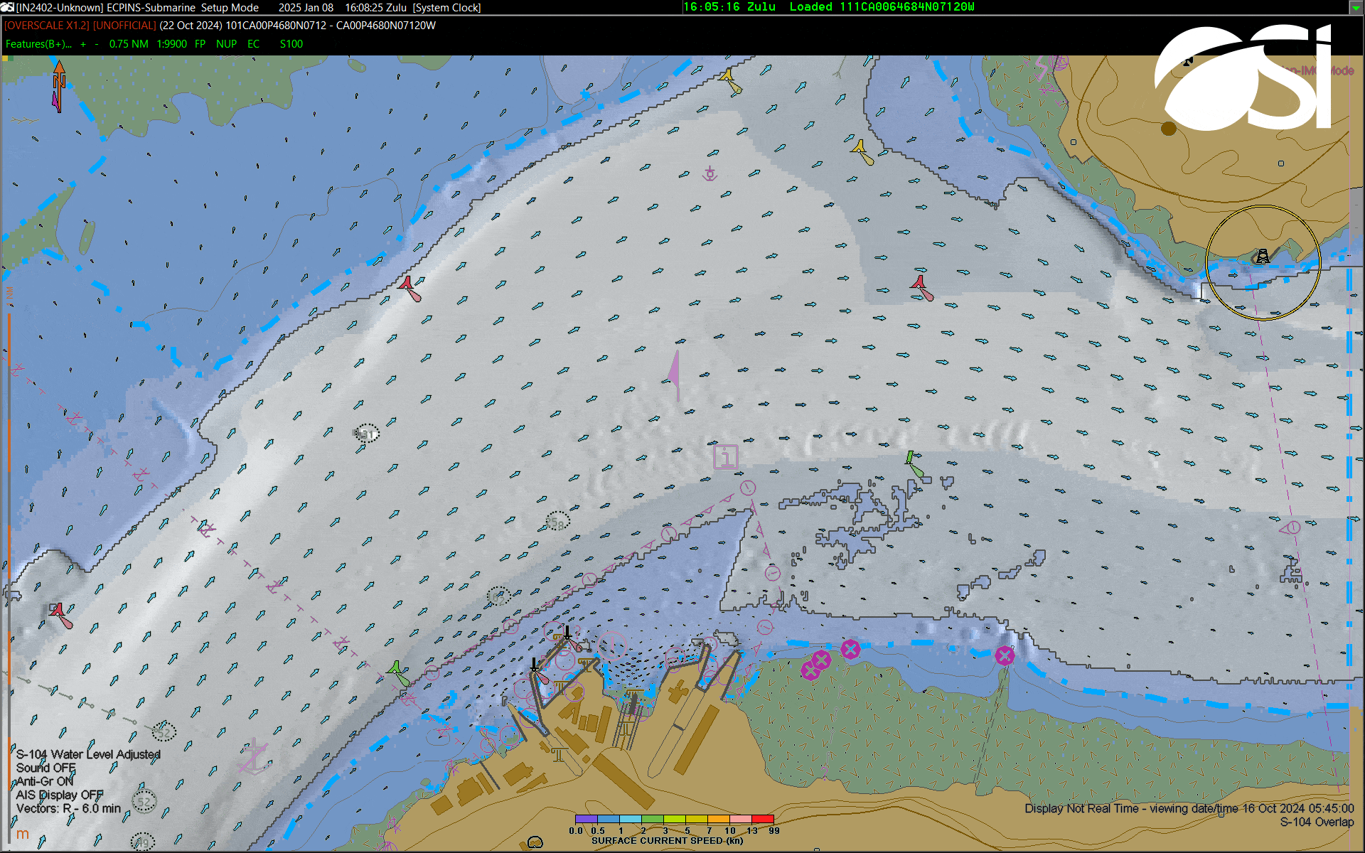
Tory Channel S-100 Testbed – New Zealand
New Zealand performed an S-100 testbed in the Tory Channel, an area known for strong currents and challenging seafloor conditions. The purpose of the testbed was to evaluate how S-101 ENCs, S-102 Bathymetric Surface, S-104 Water Level Information and S-111 Surface Currents perform compared to traditional S-57 ENCs in supporting navigational decision-making and situational awareness. This included assessing how well mariners understand a vessel’s position, movement, and interaction with the surrounding environment.
Results for channel areas covered by S-102 Bathymetric Surface showed a 19% improvement in understanding the charted environment during emergency situations, along with a 58% improvement in decision-making support during emergencies1. For S-111 Surface Currents, the testbed demonstrated clearer insights into anchor holding, vessel swing patterns, and a better understanding of why vessels behave differently in various parts of the channel1.
Image copyright: Toitū Te Whenua - Land Information New Zealand
Other IHO Member States conducting S-100 sea trials include Australia, the United Kingdom, France and the members of the Baltic Sea Regional Hydrographic Commission.
Steps Ahead
The implementation of S-100 will revolutionize the maritime industry and elevate the quality and safety of operations at sea. However, there are still key steps to implement. One of these is the pending availability of the S-100 type-approved ECDIS. While the IMO has established a transition period until 1 January 2029 for the implementation of S-100 ECDIS, commercial versions are not yet available.
However, vessels using recreational Electronic Charting Systems or Portable Pilot Units that are not subject to the IMO carriage requirement, as well as port authorities can already start using S-100 products and services. This will allow users to take advantage of the benefits of S-100 specifications and will assist with the fine-tuning in anticipation of the eventual deployment of the S-100 type-approved ECDIS.
Another constraint is the reticence of some users to shift towards S-100 due to the potential overload of information. While S-100 does provide access to a larger volume of data and sources, some of which may not always be immediately relevant to a given situation, the advantages of S-100 become evident once users learn to identify which products and information are useful in each context and how to activate or deactivate different layers.
Magnus Wallhagen, Chair of the IHO Hydrographic Services and Standards Committee (HSSC) and National Hydrographer of Sweden, explains this in more depth:
“The implementation of S-100 for the maritime world is comparable to the early days of smartphones. At first, these devices seemed unfamiliar and complex, but today, they are almost essential for day-to-day life. We expect a similar progression with S-100. As the maritime community gets familiarized with these products, users will increasingly recognize how S-100 can support their work and enhance both safety and efficiency.”
The IHO encourages national hydrographic offices and stakeholders to begin producing, testing and using S-100 data, and to provide feedback on their user end experience. Feedback on production and testing should be directed to the relevant IHO Working Group, while user feedback should be directed to the relevant maritime administration. This will enable the final product to be improved and adapted to meet the needs that mariners encounter at sea. In the meantime, the hydrographic community will continue to work to deliver the best possible framework.
----------------------------------------------------
1The testbed results were provided by LINZ, and were obtained using a combination of quantitative and qualitative methods, including surveys, situational-awareness assessments, questionnaires, live observations, and detailed debriefings. Percentage improvements were calculated by comparing the average scores for S-57 ENCs and S-100 products using the different methods.


Share this page: