Search results
There are 939 results for “capitulo 1 docx” in All
USCHC Meetings
List of US / Canada Hydrographic Commission
Cartas Circulares 2025
Circular Letters 2025
Sub-Groups
ECS PT meetings
List of ECS Project Team Meetings
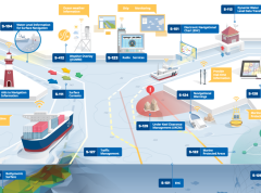
The digital twin of the navigable waters: paving the way for e-navigation
The maritime domain is in the midst of radical changes which will propel navigation forward and open a realm of new possibilities. These transformations will pave the way for e-navigation and autonomous shipping aiming to improve safety, efficiency and sustainable vessel operations. At the core of these transformations is the digital twin of navigable waters.
Guidance on use of satellites to gather depth data
The IHO has published the first “Satellite-Derived Bathymetry Best Practice Guide” for the hydrographic community. The new document provides an overview of methods and factors to consider when applying SDB to map shallow coastal environments.

Meetings
List of EAHC meetings


