The digital twin of the navigable waters: paving the way for e-navigation
Published: 21/06/2024 - 09:36The maritime domain is in the midst of radical changes which will propel navigation forward and open a realm of new possibilities. These transformations will pave the way for e-navigation and autonomous shipping aiming to improve safety, efficiency and sustainable vessel operations. At the core of these transformations is the digital twin of navigable waters.
A Digital Twin replicates real environments and processes in a digital environment, with data and information flowing from one to the other. In terms of navigable waters, the goal is to develop a consistent system of interchangeable data models, simulations and algorithms similar to those which exists on-land. Just like maps on our smart phones, where we can see roads with overlay information on real time traffic flow or points of interest. The goal is to develop the same system for the seas. This would have a base layer with detailed sea bed topography, on top of which could be added information on a variety of parameters such as ocean currents, weather forecasts, local tides and water level simulations, navigational warnings, harbour information etc.
When fed with substantive regional coverage of those data types the digital twin will be able to support enhanced marine navigation. This could include choosing an optimized route which takes advantage of currents and tides, as opposed to navigating into them; voyages can be planned based on latest depth information (taking more direct routes, or on the opposite avoiding shallow areas); coordination with port authorities and just in time arrival can decrease idle time prior to port entries by providing decision based support to increase fuel efficiency through speed reduction during ship transits; autonomous ferries could provide 24 hour service… The possibilities are endless.
The cornerstone of such a system is accurate and regularly updated data. However, this data would come from different sources (national hydrographic offices, weather service providers, harbour authorities, etc). In order for it to be integrated into a real digital twin concept, as opposed to data that is simply stacked on top of other information, the various data streams need to be standardized and interoperable so they can adjust in unison according to current real world conditions. This is where the IHO S-100 data model comes into play. While it is called the Universal Hydrographic Data Model, it is actually designed as an ecosystem to be used by all ocean disciplines. It provides standard formats so that data gathered based on its guidelines can easily be combined with other data and would be machine-readable for the seamless handling by intelligent algorithms.
The need for standardized data
Lego blocks for data
The basic elements of the S-100 ecosystem function a bit like Lego blocks: They are standardized and can be put together to form a variety of shapes: In Lego it can be a house, a castle, or even an aeroplane. Blocks from two distinct models can be combined to represent the most important parts of each.
Using this as a model to explain how S-100 works, data product specifications, their building blocks, are stored in an online library, or “Registry”, as digital elements called “features”. These are assigned certain properties called “attributes” which further describe the features. The advantage of this concept is its expandability. If new features are needed, they are defined based on the agreed S-100 design principles and are then added to the Registry.
The IHO has committed to operationalizing a series of S-100 compliant data product descriptions by the end of 2024, with as a priority those relevant for route tracking. In parallel, several IHO Member States have already announced to providing regular data services to deliver this data to the shipping industry from 2026.
Universal marine geodata model
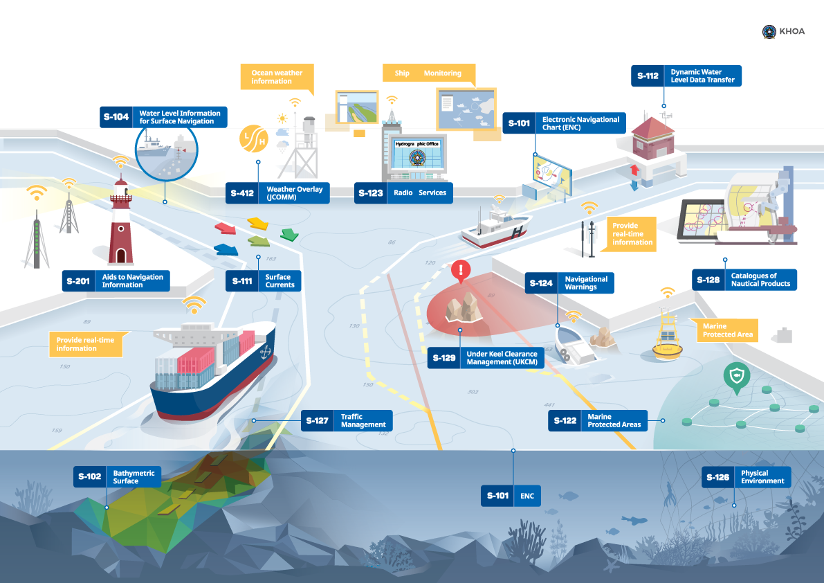
Phase 1 / Route monitoring
| S-101 | Electronic Navigational Chart (ENC) |
| S-102 | Bathymetric Surface |
| S-104 | Water Level Information for Surface Navigation |
| S-111 | Surface Currents |
| S-124 | Navigational Warnings |
| S-129 | Under Keel Clearance Management |
In 2029, S-100 all new ECDIS systems will be required to display S-100 products and services, and data services for further thematic areas will be available in a second phase. These could include:
Phase 2 / Route planning
| S-122 | Marine Protected Areas |
| S-123 | Radio Services |
| S-125 | Marine Aids to Navigation |
| S-126 | Physical Environment |
| S-127 | Traffic Management |
| S-131 | Marine Harbour Information |
| S-411 | Ice Information |
| S-412 | Weather and Marine Hazards |
In parallel, other maritime sectors are now also planning on generating data sets based on the S-100 standards. These include:
Collaborating partners associated to the S-100 Framework
| S-101 to S-199 | International Hydrographic Organization (IHO) |
| S-201 to S-299 | International Association of Light Authorities (IALA) |
| S-301 to S-399 | Intergovernmental Oceanographic Commission (IOC) |
| S-401 to S-402 | Inland ENC Harmonization Group (IEHG) |
| S-411 to S-412 | World Meteorological Organization (WMO) |
| S-421 to S-430 | International Electrotechnical Commission (IEC) |
| S-501 to S-525 | NATO Geospatial Maritime Working Group for Additional Military Layers |
“When these data deliveries come together in the end user's applications, where they are read and combined by smart software, they represent the digital twin of the navigable waters, which can then achieve, in the maritime sector, what we recognise from today’s car navigation and air traffic control systems. The S-100-based framework will fulfil the expectations we are familiar with from land-based applications: simple operation, comprehensible displays and reliable recommendations for informed decision making. Ultimately, these recommendations will be automatically executed and will enable autonomous sea transportation that is safe, efficient and gentle on people, nature, ships and cargo.”Dr Mathias Jones, IHO Secretary General
Framework already being tested.
With IMO having approved these systems for implementation as of January 2026, progress is accelerating, with systems already being tested at sea around the world.
Testing interoperability between Electronic Navigational Charts, Warnings, and Aids to Navigation.
In April 2023, the IHO-Singapore Innovation and Technology Laboratory (IHO-SG Lab) successfully carried out a test at sea to check the interoperability among S-100 Product Specifications which could be permanently updated offshore using the 4G/5G wireless network in nearly real time. The communication between Aids to Navigation (AtoNs) management and ECDIS systems, the transfer of information of Aids to Navigation and navigational warnings, as well as their visualisation on a prototype S-100 ECDIS were tested and proved feasible for future e-navigation and navigational safety. This is a collaborative project between the International Hydrographic Organization (IHO) and the International Association of Marine Aids to Navigation and Lighthouse Authorities (IALA) and was jointly carried out in Singapore with participants from the Korea Research Institute of Ships and Ocean Engineering (KRISO), Maritime and Port Authority of Singapore (MPA) and the Chair of the IHO Nautical Information Provision Working Group.
Baltic e-nav
Several countries around the Baltic Sea are participating in the Baltic e-nav project, a transnational collaboration to build capacity and ensure seamless, harmonized marine data products. It will test S-100 products from an end-user perspective to ensure the most relevant and useable navigation data possible. The recently started project will continue until 2026 and is co-financed by the EU Interreg Baltic Sea Region programme.
By using the Baltic Sea as a testbed, surrounding countries will take the next step towards the development of navigation in the Baltic Sea and implement the next generation of navigational products based on the new S-100 standard, developed by the International Hydrographic Organization (IHO). The International Maritime Organization (IMO) has agreed to require S-100 compliance in the IMO ECDIS Performance Standards (IMO, 2022) for the next generation of vessel navigation systems and has defined S-100 as the underlying data model for e-navigation (IMO, 2018).
Introducing these machine-readable products and services is a major step towards digitalized and more automated sea traffic.
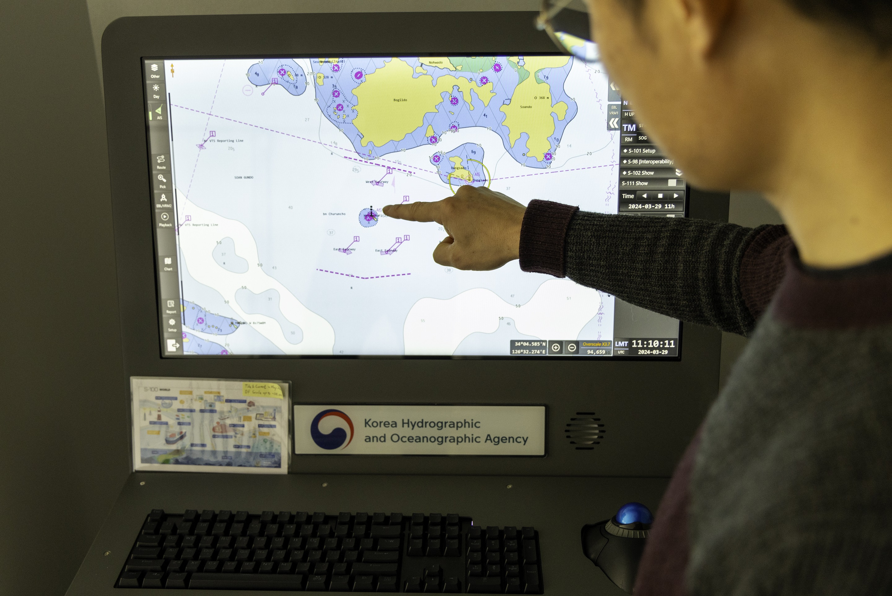
Saint Lawrence River
During the meeting of the Hydrographic Services and Standards committee (HSSC) earlier this month, Member States voted to move forwards with Canada’s proposal to use the St-Lawrence River as a Designated International S-100 Sea Trial Area for 2025. The objective is to evaluate the S-100 system's capabilities in ingesting and displaying a variety of datasets. Real-world scenarios will be tested to assess how the systems interpret different datasets in an integrated fashion. It will also test all operational versions of S-100 route monitoring layers in preparation for the official launch in January 2026. These include Electronic Navigational Charts (S-101), High-Resolution Bathymetry (S-102), Water Levels (S-104), Surface Currents (S-111), Navigational Warnings (S-124), and Underkeel Clearance Management Data (S-129). Successes and issues will be documented and reported to the IHO and IMO.


Share this page: