Search results
There are 939 results for “capitulo 1 docx” in All
World Hydrography Day
Celebrated on 21 June, World Hydrography Day highlights activities around the world and how they contribute to improved knowledge of the seas and oceans.
World Hydrography Day 2026: Transforming How Ocean Data Is Shared
Every year on 21 June, the International Hydrographic Organization (IHO) and its Member States celebrate World Hydrography Day, highlighting the vital role hydrography plays in improving our understanding of the ocean and supporting its safe, sustainable, and productive use.

Historic Outcomes at 2026 Assembly: New Leadership, New Structures, and Global Standards
Representatives of the 104 IHO Member States reached decisions which will change the future of the organization during the 4th session of the Assembly. This triennial event held in Monaco saw crucial advancements in hydrography and international collaboration including the creation of a new entity, a new office, as well as new leaders.

ENC Data Protection S-57
Introduction The IHO Data Protection Scheme defines security constructs and operating procedures that must be followed by Data Servers (providers of data) and Data Clients (systems that use the data). The purpose of data protection scheme is to provide: 1. Piracy Protection: i.e. to prevent unauthorised use of data by encrypting the ENC information. 2. Selective Access: i.e. to restrict access to ENC information to only those cells that a customer has been licenced for. 3. Authentication: i.e to provide assurance that the ENC data has come from approved sources
S-57 Encoding Bulletins
S-57 Edition 3.1 Encoding Bulletins
ENC & ECDIS
Introduction SOLAS regulations V/18 and V/19 requires that, to meet requirements for carrying charts (in terms of SOLAS), the Electronic Chart Display and Information System (ECDIS) equipment must conform to the relevant IMO performance standards. IMO resolution MSC.530(106) applied to S-100 ECDIS and thus in addition to S-57 based standards in force units must also comply with the following:
USCHC46 Meeting (2023)
46th US/Canada Hydrographic Commission (USCHC) Meeting Alabama, 16-17 March 2023
USCHC45 Meeting (2022)
45th US/Canada Hydrographic Commission (USCHC) Meeting Ottawa, 9-10 June 2022
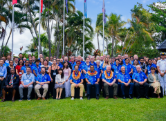
Mapping the Future: Fiji Hosts Pivotal Meetings on Ocean Mapping and Hydrography
Suva & Nadi, Fiji — November 2024 Fiji became the epicenter of global ocean mapping, hydrographic collaboration and geospatial information management as it hosted a series of landmark meetings with a strong focus on Pacific engagement. From the 41st Meeting of the GEBCO Guiding Committee (GGC41) and the 6th Pacific Ocean Mapping Meeting to the subsequent UN workshops on geospatial frameworks and sustainable development, the events underscored the critical role of ocean and data governance for Pacific Island countries and territories.