Search results
There are 943 results for “capitulo 1 docx” in All
JWG-MGI
UN-GGIM – IHO Joint Working Group on Marine Geospatial Information (JWG-MGI)
Funded Opportunities for Training & Sea Survey Experience
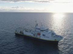
As part of its ongoing commitment to strengthening hydrographic capacity worldwide, the IHO is pleased to share that several fully-funded opportunities for training and hands-on survey experience are currently open for applications, including a call to participate in a trans-Atlantic hydrographic survey.
Major Flag State Joins the International Hydrographic Organization
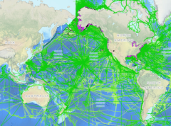
The global hydrographic community expanded in January 2026 with the accession of Panama to the International Hydrographic Organization (IHO), marking a significant milestone for international maritime cooperation. As one of the world’s major flag states and a strategic hub for global shipping, Panama’s membership is expected to strengthen hydrographic capacity and standards worldwide.
Seabed Mapping: Enabling Ocean Action - World Hydrography Day 2025
Seabed mapping supports all activities centred on the ocean, from safety of navigation to marine conservation, marine renewable energy, coastal resilience, and the ocean economy. This includes charting new shipping routes in polar regions to providing up-to-date data to improve climate change models.
Cartas Circulares de la Asamblea
S-57 ENC Portrayal
Introduction IHO Publication S-52 was developed in conjunction with the IMO Performance Standards for Electronic Chart Display and Information System (ECDIS). It provides specifications and guidance regarding the issuing and updating of Electronic Navigational Charts (ENC), and their display in ECDIS in terms of symbols and colours.
MEETINGS AFTER 2024
List of the South-East Pacific Regional Hydrographic Commission Meetings Note: To access the meeting page, you'll need an IHO Portal account. If you don't have one yet, don't worry! Creating an account is easy. Simply follow the instruction provided at the link here to set up your account and gain access to the meeting page. Click the IHO Portal to get started
MEETINGS AFTER 2024
List of the South West Atlantic Hydrographic Commission (SWAtHC) Meetings Note: To access the meeting page, you'll need an IHO Portal account. If you don't have one yet, don't worry! Creating an account is easy. Simply follow the instruction provided at the link here to set up your account and gain access to the meeting page. Click the IHO Portal to get started
IHO DCDB - temporary app during NCEI outage
Hurricane Helene caused severe damage to several areas of the East Coast of the USA, which in turn has significantly impacted the operations of NOAA's National Centers for Environmental Information (NCEI) in Asheville. Many of their systems including the online access to IHO DCDB-archived bathymetric data are currently down.