Search results
There are 939 results for “capitulo 1 docx” in All
IHO Crowdsourced Bathymetry Initiative
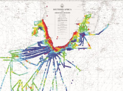
The International Hydrographic Organization (IHO) has a long history of encouraging the collection of crowdsourced depth data to help improve humanity’s understanding of the shape and depth of the seafloor. For over a century, maps of the ocean floor were created from depth measurements collected by vessels as they journeyed across the oceans. These “passage soundings” enabled the creation of progressively more detailed seafloor maps and digital data grids. Recently, systematic surveys with specialized ships have contributed to greatly increasing available data. Unfortunately, despite the multitude of data that has been collected, to this day only 25% of the world’s ocean depths have been measured; the rest of the data used to compile seafloor maps are estimated depths.
Intersession Meetings
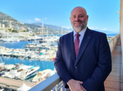
New IHO Director presents his background & future objectives
Following the elections during the 3rd session of the IHO Assembly, Dr. John Nyberg has formally taken up his role as IHO Director at the Secretariat in Monaco. In order to get to know him better, we asked him questions about his background and aspirations for his tenure at the IHO Secretariat.
TWCWG8 (2024)
8th Tides, Water Level and Currents Working Group (TWCWG8) VTC 20 Feb - 22 Feb 2024 Online Registration
Basic PT Documents
HSWG5
HSWG6
What is progress with crowd-sourced depth data around the world?
The Crowdsourced Bathymetry Working Group met last week to discuss progress on an IHO-led citizen science initiative to collect seafloor depth data. Discussions focused on updating guidance and learning about progress from some of the first trial projects around the world.