Search results
There are 1138 results for “” in All
WWNWS16 (2024)
16th Meeting of World Wide Navigational Warning Service Sub-Committee (WWNWS16) VALPARAÍSO, CHILE, 02 - 06 SEPTEMBER 2024
What is progress with crowd-sourced depth data around the world?
The Crowdsourced Bathymetry Working Group met last week to discuss progress on an IHO-led citizen science initiative to collect seafloor depth data. Discussions focused on updating guidance and learning about progress from some of the first trial projects around the world.
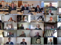
Document Review Working Group - DRWG22 (2024)
Document Review Working Group (DRWG22) - VTC via MS Teams (12-14 March) 0800-1200 UTC
Document Review Working Group - DRWG23 (2025)
Document Review Working Group (DRWG23) - VTC via MS Teams (11-13 March 2025) 0800-1200 UTC
GI Registry
Introduction S-100 Geospatial Information Registry contains several registers (online databases) that include items of information that are relevant to those communities developing of S-100 based products and services.
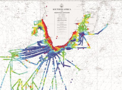
Worldwide ENC Database working group discusses the future of coverage
The Worldwide ENC Database working group (WEND) gathered last week to discuss the future of global ENC coverage, decisions which are key to support the safety of navigation, search and rescue activities, and mitigate the impacts of storms, marine pollution etc. The goal was to pave the way and be ready for when the new S-100 based digital products are implemented, and to try and coordinate initiatives.
SCRUM9
Remote meeting held over two sessions: 1 of 2 - 12:00 - 13:00 UTC - 2 Nov 2021 2 of 2 - 13:00 - 14:00 UTC - 11 Nov 2021
MASS PT
Maritime Autonomous Surface Ships (MASS) Navigation Project Team (PT) One area of concern of MASS PT is the current lack of specific navigational data that is required to “drive” a MASS or more importantly the lack of any stated rules, regulations or standards relating to navigational data in MASS.
Videos
Collection of videos about S-100 development, testing, and best practices.


