Search results
There are 939 results for “capitulo 1 docx” in All
Basic PT Documents
Basic PT Documents
HSWG3
The IHO welcomes its 98th Member State
The International Hydrographic Organization is increasing its ranks with the accession of Albania as its 98th Member State.
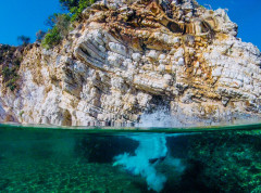
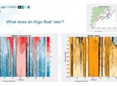
From ocean mapping to Argo floats: how are we learning about the changing ocean?
Better ocean data can be used to inform a variety of decisions from storm preparedness to seaweed farming. As part of the Monaco Ocean Week, the IHO hosted an event which provided an overview of some of the work being done to increase our knowledge of the ocean, from Prince Albert I of Monaco’s original idea of ocean mapping to the Argo programme, an exciting, global multidisciplinary project.
Portrayal Catalogue Builder
Portrayal Catalogue Builder (PCB)
New editor for the International Hydrographic Review
The International Hydrographic Review, the scientific journal published by the IHO, has a new editor. Dr Patrick Westfeld began his new functions on 5 January 2022. He brings with him solid technical knowledge, coupled with good experience with academia and scientific publishing.