Search results
There are 238 results for “sea” in All
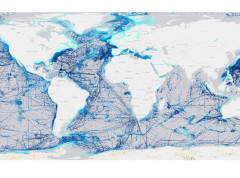
IHO Crowdsourced Bathymetry Initiative
The International Hydrographic Organization (IHO) has a long history of encouraging the collection of crowdsourced depth data to help improve humanity’s understanding of the shape and depth of the seafloor. For over a century, maps of the ocean floor were created from depth measurements collected by vessels as they journeyed across the oceans. These “passage soundings” enabled the creation of progressively more detailed seafloor maps and digital data grids. Recently, systematic surveys with specialized ships have contributed to greatly increasing available data. Unfortunately, despite the multitude of data that has been collected, to this day only 25% of the world’s ocean depths have been measured; the rest of the data used to compile seafloor maps are estimated depths.
Meso American & Caribbean Sea HC
E-Navigation and GMDSS
Introduction E-navigation is defined as “the harmonized collection, integration, exchange, presentation and analysis of marine information on board and ashore by electronic means to enhance berth to berth navigation and related services for safety and security at sea and protection of the marine environment.” It is intended to meet present and future user needs through harmonization of marine navigation systems and supporting shore services.
Events & recordings
Date Event Link 21 May 2024 SWPHC S-100 Workshop – Benefits of S-100 Presentations Electronic Chart Centre (ECC) SHOM & UKHO KRISO Recording 30 April 2024 workshop on Ed 5.2.0 on the S100 standard Presentation Recording 22 November 2023 SWPHC S-100 Workshop #3 – S-100 Implementation Agenda Presentations: Australia (AHO) New Zealand (LINZ) USA (NOAA) United Kingdom (UKHO) IIC IC-ENC Recording May 2023 Hydrographic Leaders Programme Pilot evaluation report Pilot evaluation headlines (presentation) Report Presentation 5th Pacific Regional Energy & Transport Ministers Meeting Technical Information Paper TI06: The International Hydrographic Organization (IHO) Strategic Plan 2021- 2026 and the South West Pacific Hydrographic Commission (SWPHC) Workplan. Agenda TI06 IHO/SWPHC Intervention Intervention & photo SWPHC, SPC, IMO and IALA Photo 22-24 February 2023 3-Day SWPHC20 Meeting Agenda Agenda Item 12: Hydrographic Leaders Programme (intro to session) Presentation Recording Agenda Item 13: Hydrographic Leaders Programme (group feedback) Presentation Recording Agenda Item 14: Empowering Women in Hydrography (intro) Presentation Recording Agenda Item 14: Empowering Women in Hydrography (online group) Recording Agenda Item 15: Safety of Navigation: Delivering as one Presentation Recording Agenda Item 16: Building Partnerships: Understanding the World Bank Presentation Recording Agenda Item 16: UNGGIM Integrated Geospatial Information Framework (IGIF) - Implementation case studies Philippines Kiribati Recording Presentation Presentation Agenda Item 21.2: Update from Marine Spatial Data Infrastructure Working Group (MSDIWG) Presentation Recording 14 February 2023 1-Day SWPHC20 VTC Pre-meeting Agenda Agenda Item 2: Cybersecurity Presentation Recording Agenda Item 3: UNGGIM Integrated Geospatial Information Framework (IGIF-H) – Implementation case studies Presentation Recording Agenda Item 11: Empowering Women in Hydrography Presentation Recording Agenda Item 12: Hydrographic Leaders Programme Presentation Recording 15,16 & 18 November 2022 Pacific Regional Transport Officials Meeting The IHO Strategic Plan 2021-2026 and the SWPHC Work Plan Agenda Paper Presentation 12 October 2022 SWPHC S-100 Workshop #2 – Updates and Value Proposition Agenda Presentations: Australia (AHO) New Zealand (NZHA) Australia (AHO) Fiji (FHS) USA (NGA) Singapore (MPA) France (SHOM) Recording 1 July 2022 SWPHC Seabed 2030 Webinar #4: Moving ahead together: Summary, next steps and wrap-up Presentation Recording Photo 21 June 2022 SWPHC Seabed 2030 Webinar #3: CSB and the role of HOs and other data collectors Presentation Recording Photo 24 May 2022 SWPHC Seabed 2030 Webinar #2: Building the Map. How do we build the map? How can you access & contribute data? Presentation Recording Photo 10 May 2022 SWPHC Seabed 2030 Webinar #1: Where are we now? Introduction, Goals & Status of Mapping in the Region Presentation Recording 23-25 Feb 2022 SWPHC19 Agenda Item 12 SWPHC Draft Work Plan 2021-2026 Recording SWPHC19 Agenda Item 13 UNGGIM Integrated Geospatial Information Framework (IGIF) & Open Data – the value proposition Recording 17 Dec 2021 Hydrographic Leadership Programme Q&A Webinar Photo1 - Photo2 - Photo3 27 Oct 2021 S-100 Workshop #1 – experiences in implementing S-100 Recording Presentations: France New Zealand Australia United Kingdom Fiji 22 Sept 2021 Extratropical Surge and Tide Operational Forecast System (ESTOFS) Workshop Recording Presentation
Folleto de la OHI
Si desean información adicional, pueden acceder aquí al Folleto de la OHI.
ABLOS26 (2019)
26th Advisory Board on Law of the Sea (ABLOS) Business Meeting (7 & 10 October 2019) IHO Secretariat, Monaco
SCRUM
SUB-COMMITTEE ON REGIONAL UNDERSEA MAPPING (SCRUM)
BSHC28 (2023)
LIST OF DOCUMENTS 28th Meeting Helsinki, Finland, 19 - 21 September 2023 Post Meeting Documents: [Photo] [Minutes] [Actions] Updated: 21 November 2023 Document No Document Title Date BSHC28-Registration Link to online registration - BSHC28-Letter1 BSHC28 Letter of Invitation 22 May BSHC28-Letter1 Annex A Draft Programme 22 May BSHC28-Letter1 Annex B Draft Agenda V2 22 May BSHC28_A1.2_List_Documents List of Documents - see this website BSHC28_A1.3_List_of-Participants List of Participants - BSHC28_A3_Agenda V 3 Agenda for 28th Meeting of the BSHC 21 Aug BSHC28_A4.1_BSHC27_Final_Minutes BSHC27 Final Meeting Minutes BSHC28_A4.2_BSHC27_List_of_Actions BSHC27 List of Actions BSHC28_B1_IHO IHO Secretariat Report 13 Sep BSHC28_B2_SE (Presentation) Council Report 23 Aug BSHC28_B3.1_National_Report_Denmark (Presentation) National Report of Denmark 18 Sep BSHC28_B3.2_National_Report_Estonia (Presentation) National Report of Estonia 21 Aug BSHC28_B3.3_National_Report_Finland (Presentation) National Report of Finland 21 Aug BSHC28_B3.4_National_Report_Germany (Presentation) National Report of Germany 21 Aug BSHC28_B3.5_National_Report_Latvia National Report of Latvia 8 Sep BSHC28_B3.6_National_Report_Lithuania (Presentation) National Report of Lithuania 21 Aug BSHC28_B3.7_National_Report_Poland (Presentation) National Report of Poland 21 Aug BSHC28_B3.8_National_Report_Sweden (Presentation) National Report of Sweden 23 Aug BSHC28_C1 HSSC15 Report 23 Aug BSHC28_C2 (Presentation) Report fo Re-Survey Monitoring Working Group (MWG) 21 Aug BSHC28_C3 (Presentation) Chart Datum WG Report (CDWG) 21 Aug BSHC28_C4 BSHC Test data for S-130PT 21 Aug BSHC28_D1 Status report BSHC Strategic Correspondence Group (CSG) 21 Aug BSHC28_D2 (Presentation) Actions requested by IRCC15 21 Aug BSHC28_D3 (Presentation) IHO-EU Network Report 23 Aug BSHC28_D4 (Presentation) Report of the Baltic Sea Bathymetric Database Working Group (BSBDWG) BSHC28_D5 (Presentation) Report of Baltic Sea North Sea Marine Spatial Data Information Working Group (BSNSMSDIWG) 21 Aug BSHC28_D6 (Presentation) Report of the Baltic Sea MSI Working Group (BSMSIWG) 21 Aug BSHC28_D6.1 (Presentation) Nordstream Incident 21 Aug BSHC28_D7 (Presentation) Report of the BSHC representative to WENDWG 28 Aug BSHC28_D8 (Presentation) Report of Baltic Sea INT Chart Coordination Working Group (BSICCWG) 21 Aug BSHC28_D9 IHO Capacity Building Sub-Committee (CBSC) Issues Review BSHC28_D10 BSHC Website 21 Aug BSHC28_D11 Baltic Sea e-Nav Project 23 Aug BSHC28_E.1 NGAs Global Maritime Traffic Density Service GMTDS 8 Sep BSCH28_Presentations Presentations.zip BSHC28_Draft_Actions Draft Actions BSHC28_Draft_Minutes Draft Minutes
BSHC29 (2024)
LIST OF DOCUMENTS 29th Meeting Tallinn, Estonia, 17 - 19 September 2024 Post Meeting Documents: [Photo] [Minutes] [Actions] Updated: 3 December 2024 Document No Document Title Date BSHC29-Registration Link to online registration 29 May 2024 BSHC29-Letter1 BSHC29 Letter of Invitation 29 May 2024 BSHC29-Letter1 Annex A Draft Programme 4 September 2024 BSHC29-Letter1 Annex B Draft Agenda V3 16 September 2024 BSHC29_A1.2_List_Documents List of Documents - see this website BSHC29_A1.3_List_of_Participants List of Participants 2 August 2024 BSHC29_A3_Agenda V3 Agenda for 29th Meeting of the BSHC 2 August 2024 BSHC29_A4.1_BSHC28_Final_Minutes BSHC28 Final Meeting Minutes BSHC29_A4.2_BSHC28_List_of_Actions BSHC28 List of Actions BSHC29_B1_IHO (Presentation) IHO Secretariat Report 25 September 2024 BSHC29_B2_SE (Presentation) Council Report 2 August 2024 BSHC29_B3.1_National_Report_Denmark (Presentation) National Report of Denmark 16 September 2024 BSHC29_B3.2_National_Report_Estonia (Presentation) National Report of Estonia 17 September 2024 BSHC29_B3.3_National_Report_Finland (Presentation) National Report of Finland 25 September 2024 BSHC29_B3.4_National_Report_Germany (Presentation) National Report of Germany 25 September 2024 BSHC29_B3.5_National_Report_Latvia (Presentation) National Report of Latvia 17 September 2024 BSHC29_B3.6_National_Report_Lithuania (Presentation) National Report of Lithuania 16 September 2024 BSHC29_B3.7_National_Report_Poland (Presentation) National Report of Poland 17 September 2024 BSHC29_B3.8_National_Report_Sweden (Presentation) National Report of Sweden 25 September 2024 BSHC29_B4 IHO Strategic Plan Review and BSHC Input 16 September 2024 BSHC29_C1 HSSC16 Report 2 August 2024 BSHC29_C2 (Presentation) Report fo Re-Survey Monitoring Working Group (MWG) 25 September 2024 BSHC29_C3 (Presentation) Chart Datum Waterlevel and Currents WG Report (CDWCWG) 16 September 2024 BSHC29_C4 (Presentation) S-100 Implementation Activities in Finland 3 September 2024 BSHC29_C5 (Presentation) New symbology for rocky areas in Nautical Charts 3 September 2024 BSHC29_C6 Annex 1 Annex 2 (Presentation) S-127 3 September 2024 BSHC29_D1 (Presentation) Actions requested by IRCC16 BSHC29_D2 (Presentation) IHO-EU Network Report BSHC29_D3-1 (Presentation) Report of the Baltic Sea Bathymetric Database Working Group (BSBDWG) 3 September 2024 BSHC29_D3-2 (Presentation) EMODNET Report 25 September 2024 BSHC29_D3-3 (Presentation) CSB-GEBCO-SEABED2030 Report 3 September 2024 BSHC29_D4 (Presentation) Report of the Baltic Sea MSI Working Group (BSMSIWG) 25 September 2024 BSHC29_D5 (Presentation) Report of the BSHC representative to WENDWG 17 September 2024 BSHC29_D6 (Presentation) Report of Baltic Sea INT Chart Coordination Working Group (BSICCWG) 17 September 2024 BSHC29_D7 MSDI Issues 4 September 2024 BSHC29_D8 IHO Capacity Building Sub-Committee (CBSC) Issues Review BSHC29_D9 BSHC Website 3 September 2024 BSHC29_D10 Baltic Sea eNav Project 10 September 2024 BSHC29_E2 BSHC Participation at the EC Expert Group and EGSMW 16 September 2024 BSHC29_Presentations Presentations.zip BSHC29_Draft_Actions Draft Actions BSHC29_Draft_Minutes Draft Minutes