New guide on accuracy of depth information in Electronic Navigational Charts - ENCs
Published: 20/10/2020 - 13:18Data provided in electronic navigational charts can vary greatly in accuracy depending on when the sea survey to gather the data was carried out, the type of technology used, as well as the seafloor coverage.
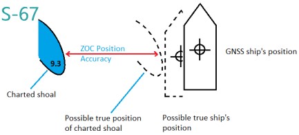
and in depth up to +/- 7 metres.
In some areas, the actual location of potential dangers may substantially differ horizontally and vertically from what is charted. In order to help mariners make informed decisions based on the data in their on-board navigation systems, the IHO has released a new guide on how to assess the accuracy and reliability of depth information and position in Electronic Navigational Charts (S-67).
One of the key features of this guide is an explanation about the “Zone of Confidence”, a category system describing accuracy levels. The source data is classified in six categories, ranging from high accuracy to poor accuracy at the other end of the spectrum, and one category of “Unassessed”. The differences in the quality of the data could mean the depiction of the location of obstacles can vary in accuracy from +/- 5 metres to over 500 metres, and vary in depth from +/- 0.5 metres to over +/- 7 metres. Considering that only 5% of the world’s coastal waters are classed as having the highest accuracy depth information, it shows how vital it is for mariners to fully understand how to evaluate displayed information.
Overall availability and accuracy of survey data has increased since the 1990s thanks to progress in technology and in particular the use of GPS. Every year our knowledge of the ocean improves, which could give some the impression that what is represented on charts is 100% accurate. While modern satellite imagery can be used to correct the position of many isolated visible offshore features, such as islands or reefs, anything a few meters below the surface is likely to remain unseen, and therefore possibly charted away from its true position. There is still much we do not know, and many places remain either unsurveyed or with out-of-date information.
“The data for some nautical charts is still extracted from surveys carried out more than 100 years ago. Not only could the marine environment have changed in that time, but now technology has improved, meaning we could get more precise information.
Dr Mathias Jonas, IHO Secretary General
Whereas on paper charts the source diagrams provide information on the source of the data from which we could infer about the accuracy, things are not always as clear with digital solutions. Electronic Chart Display and Information Systems (ECDIS) include information on the accuracy of the data, but to view the Zones of Confidence symbology, mariners must activate the “information on chart display layer”. As this clutters the screen, some deactivate it during the route planning and journey. The goal of the new IHO guide is to provide more information about the different accuracy levels so mariners fully grasp the potential difference between the information displayed and where an obstacle could actually be.
“Good data quality does not mean that the quality of the data is good, it means that the end-user is well informed how good the quality of the data is.
Rogier Broekman
This issue will take on even more importance with the development of autonomous shipping: for ships to be able to navigate safely, there needs to be a data quality measure which is machine readable.
Rogier Broekman, Head of the Geodesy & Tides section of the Royal Netherlands Navy Hydrographic Service, led the IHO Data Quality working Group which put together this “Mariners’ Guide to Accuracy of Depth Information in ENC” (IHO publication S-67). It was designed to complement IHO Publication S-66 –“Facts about Electronic Charts and Carriage Requirements” so as to provide a more “in-depth” knowledge as to how a navigator should interpret the information presented to them. Readers are also encouraged to consult guidance regarding national policies on the category of depth accuracy information applied in ENCs, such as Mariners’ Handbooks and national hydrographic authority websites where they exist.
As Yves Guillam, Assistant Director at the IHO Secretariat, says “It is better to ignore absolutely where we are, and to know we do not know, than to believe with confidence we are somewhere where we are not” (quoting Jacques Cassini (1722)).
Various industry representatives participated in the working group and provided input for the development of this guide, including shipping and cruise companies.


Share this page: