Search results
There are 1138 results for “” in All
S-100WG4 (2019)
4th S-100 Working Group (S-100WG) Meeting Aalborg, Denmark (27 Feb - 1 March 2019)
ECS PT1 (2023)
1st Meeting of Electronic Chart System Project Team 18 July 2023 / Bristol, UK + VTC / 10:00 - 15:35 (UTC+2/CEST) Online Registration
ENCWG6 (2021)
6th ENC Standards Maintenance Working Group Meeting (ENCWG6) Online Meeting 15 - 17 June / VTC
ENCWG5 (2020)
5th ENC Standards Maintenance Working Group Meeting (ENCWG5) Online Meeting 15 July (12:00 to 15:00 CEST) 16 July (12:00 to 15:00 CEST)
ENCWG4 (2019)
4th ENC Standards Maintenance Working Group Meeting (ENCWG4) IHO, Monaco 10 - 12 June 2019 Post Meeting Documents: [ENCWG4 Draft Minutes] [Draft Actions List] [Meeting Photo]
ENCWG VTC (2022)
ENCWG VTC Meetings 2022 Online Meeting
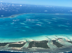
Global hydrographic community grows with 100th country joining the IHO
The Republic of Kiribati has officially become the 100th Member State of the International Hydrographic Organization (IHO), marking a significant milestone for the global hydrographic community. This historic landmark opens up numerous benefits of being an IHO Member State, from helping carry out obligations under the SOLAS Convention, to enhancing safety of navigation, maritime security, fisheries management, economic growth, environmental protection, and climate resilience.
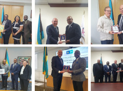
The IHO visits the Commonwealth of the Bahamas
On invitation of the Bahamian Ministry of Foreign Affairs, IHO Director Luigi Sinapi paid a High Level Visit to the Commonwealth of The Bahamas from 15 to 19 April. The Visit was aimed at resuming discussions on the Bahamas’ potential membership to the International Hydrographic Organization and on the progress made in the maritime sector of The Bahamas, to further strengthening the national capacity in the area of hydrography and improving the current Bahamian Maritime National Policy.
How to Get Involved
Welcome to the world of crowdsourced bathymetry (CSB), where collective efforts can help shape our understanding of the depths in our coastal zones, oceans, lakes, and waterways. This approach harnesses the power of individuals and organizations worldwide to contribute to and create improved bathymetric maps and products. Join our crowdsourced bathymetry effort and contribute to the exploration of the world's oceans like never before! We invite scientists and researchers, navigators, fishers, like-minded enthusiasts, and anyone with a passion for the mysteries that lie beneath the waves. Together, we can help create a comprehensive and accurate map of the ocean floor, unlocking valuable insights into marine ecosystems, geological processes, and potential resources. By pooling our collective knowledge and data, we can accelerate scientific discovery and conservation efforts. Whether you have access to specialized equipment or are simply an avid sailor, your contributions can make a difference.


