Search results
There are 1138 results for “” in All
CBSC 21 - (2023) Intersessional Meeting
VTC 13 March 2023 11h00 - 14h30 (CET UTC+1)
CBSC 19 - (2021) Intersessional Meeting
25 -26 February 2021 11h00 - 13h00 (CET UTC+1)
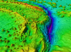
Participants in GEBCO week discuss seafloor mapping and knowledge of the oceans
Over 600 participants from 80 countries gathered online as part of the GEBCO Week to discuss initiatives to map the seafloor and increase our knowledge of the oceans.
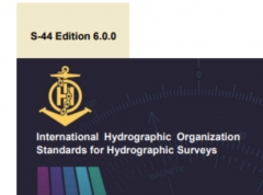
IHO releases new standards for hydrographic surveys
The IHO released earlier this month a new edition of the Standards for Hydrographic surveys (S-44). In addition to surveys to support the safety of navigation, these standards can be adapted for oil and gas, renewable energies, dredging, geophysics, and geotechnics.
Audience with HSH Prince Albert II & priorities for the new Directing Committee
The new IHO Directing Committee was presented to HSH Prince Albert II of Monaco on Tuesday September 8th 2020.

Vital services continue around the world
Despite the covid-19 pandemic and many people across the world having to work from home, Hydrographic Offices around the globe can be proud of the work they are doing to continue to ensure safety at sea and other vital maritime services. Hydrographic Offices have had to adapt to new circumstances and are successfully ensuring that critical operations move forwards. Maritime Safety Information continues to be shared, NAVAREAs covered, and even the production and maintenance of digital nautical charts (ENCs) and relevant online marine data services is continuing despite constraints linked with the pandemic.
TWCWG - Vertical Reference Frame GNSS Datum details
Tides, Water Level and Currents Working Group (TWCWG) VERTICAL REFERENCE FRAME GNSS DATUMS Datum Details Supplied for General Analysis and Comparison
Reference Documents
Last Update: 4 February 2021
SCRUM8
Remote meeting hosted by IOC, Paris, France - 11 to 15 January 2021 (Online Symposium/Seabed 2030 - 11-15 January 2021)


