Search results
There are 362 results for “sea” in All
North Sea Hydrographic Commission 37 Malmo, Sweden, 9-10 April
28th Conference of the Baltic Sea Hydrographic Commission Helsinki, Finland, 19 - 21 September
27th Conference of the Baltic Sea Hydrographic Commission Stockholm, Sweden, 20 - 22 September
9th Session of the IMO Sub-Committee on Navigation, Communications and Search and Rescue Remote virtual meeting, 21 to 30 June
Events & recordings
Date Event Link 21 May 2024 SWPHC S-100 Workshop – Benefits of S-100 Presentations Electronic Chart Centre (ECC) SHOM & UKHO KRISO Recording 30 April 2024 workshop on Ed 5.2.0 on the S100 standard Presentation Recording 22 November 2023 SWPHC S-100 Workshop #3 – S-100 Implementation Agenda Presentations: Australia (AHO) New Zealand (LINZ) USA (NOAA) United Kingdom (UKHO) IIC IC-ENC Recording May 2023 Hydrographic Leaders Programme Pilot evaluation report Pilot evaluation headlines (presentation) Report Presentation 5th Pacific Regional Energy & Transport Ministers Meeting Technical Information Paper TI06: The International Hydrographic Organization (IHO) Strategic Plan 2021- 2026 and the South West Pacific Hydrographic Commission (SWPHC) Workplan. Agenda TI06 IHO/SWPHC Intervention Intervention & photo SWPHC, SPC, IMO and IALA Photo 22-24 February 2023 3-Day SWPHC20 Meeting Agenda Agenda Item 12: Hydrographic Leaders Programme (intro to session) Presentation Recording Agenda Item 13: Hydrographic Leaders Programme (group feedback) Presentation Recording Agenda Item 14: Empowering Women in Hydrography (intro) Presentation Recording Agenda Item 14: Empowering Women in Hydrography (online group) Recording Agenda Item 15: Safety of Navigation: Delivering as one Presentation Recording Agenda Item 16: Building Partnerships: Understanding the World Bank Presentation Recording Agenda Item 16: UNGGIM Integrated Geospatial Information Framework (IGIF) - Implementation case studies Philippines Kiribati Recording Presentation Presentation Agenda Item 21.2: Update from Marine Spatial Data Infrastructure Working Group (MSDIWG) Presentation Recording 14 February 2023 1-Day SWPHC20 VTC Pre-meeting Agenda Agenda Item 2: Cybersecurity Presentation Recording Agenda Item 3: UNGGIM Integrated Geospatial Information Framework (IGIF-H) – Implementation case studies Presentation Recording Agenda Item 11: Empowering Women in Hydrography Presentation Recording Agenda Item 12: Hydrographic Leaders Programme Presentation Recording 15,16 & 18 November 2022 Pacific Regional Transport Officials Meeting The IHO Strategic Plan 2021-2026 and the SWPHC Work Plan Agenda Paper Presentation 12 October 2022 SWPHC S-100 Workshop #2 – Updates and Value Proposition Agenda Presentations: Australia (AHO) New Zealand (NZHA) Australia (AHO) Fiji (FHS) USA (NGA) Singapore (MPA) France (SHOM) Recording 1 July 2022 SWPHC Seabed 2030 Webinar #4: Moving ahead together: Summary, next steps and wrap-up Presentation Recording Photo 21 June 2022 SWPHC Seabed 2030 Webinar #3: CSB and the role of HOs and other data collectors Presentation Recording Photo 24 May 2022 SWPHC Seabed 2030 Webinar #2: Building the Map. How do we build the map? How can you access & contribute data? Presentation Recording Photo 10 May 2022 SWPHC Seabed 2030 Webinar #1: Where are we now? Introduction, Goals & Status of Mapping in the Region Presentation Recording 23-25 Feb 2022 SWPHC19 Agenda Item 12 SWPHC Draft Work Plan 2021-2026 Recording SWPHC19 Agenda Item 13 UNGGIM Integrated Geospatial Information Framework (IGIF) & Open Data – the value proposition Recording 17 Dec 2021 Hydrographic Leadership Programme Q&A Webinar Photo1 - Photo2 - Photo3 27 Oct 2021 S-100 Workshop #1 – experiences in implementing S-100 Recording Presentations: France New Zealand Australia United Kingdom Fiji 22 Sept 2021 Extratropical Surge and Tide Operational Forecast System (ESTOFS) Workshop Recording Presentation
8th Session of the IMO Sub-Committee on Navigation, Communications and Search and Rescue Remote virtual meeting, 19 – 23 April
World Oceans Day video
How can mapping the seabed contribute to initiatives like the Ocean Decade? The IHO produced a video for World Oceans Day which highlights some of the ways hydrography can contribute to increasing our knowledge of the ocean.

21st Meeting of the Meso American & Caribbean Sea Hydrographic Commission (MACHC21) Video-teleconference (VTC), 30 November to 3 December
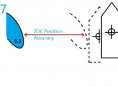
New guide on accuracy of depth information in Electronic Navigational Charts - ENCs
Data provided in electronic navigational charts can vary greatly in accuracy depending on when the sea survey to gather the data was carried out, the type of technology used, as well as the seafloor coverage.