Search results
There are 362 results for “sea” in All
Circular Letters
The IHO Secretariat communicates important information to Member States (MS) via Circular Letter (CL). Some CLs invite Member States to provide feedback to the Secretariat (e.g. approval of new editions of IHO Standards). In cases where MSs are invited to provide feedback via online form, the link to the form will be included in the CL. Further information is provided in CL 20/2019). All previous years CLs are available from the IHO searchable HERE. ________________ Spanish Circular Letters are available HERE
MEETINGS AND CONFERENCES AFTER 2024
List of ABLOS Meetings and Conferences Note: To access the meeting page, you'll need an IHO Portal account. If you don't have one yet, don't worry! Creating an account is easy. Simply follow the instruction provided at the link here to set up your account and gain access to the meeting page. Click the IHO Portal to get started ABLOS Meetings and Conferences Year Title Venue Date Remarks 2025 32nd ABLOS Business Meeting Doha, Qatar 6 and 9 October 2025 IHO Portal 2025 12th IHO-IAG Advisory Board on the Law of the Sea (ABLOS) Conference PROGRAMME (For more information and to register, please consult the ABLOS Website) Doha, Qatar 7 and 8 October 2025 ABLOS Website
E-Navigation and GMDSS
Introduction E-navigation is defined as “the harmonized collection, integration, exchange, presentation and analysis of marine information on board and ashore by electronic means to enhance berth to berth navigation and related services for safety and security at sea and protection of the marine environment.” It is intended to meet present and future user needs through harmonization of marine navigation systems and supporting shore services.
29th Conference of the Baltic Sea Hydrographic Commission (BSHC) Tallinn, Estonia 18 – 19 September
24th Conference of the Mediterranean and Black Seas Hydrographic Commission (MBHSC) Constanta, Romania, 2 – 4 July
How to Get Involved
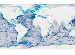
Welcome to the world of crowdsourced bathymetry (CSB), where collective efforts can help shape our understanding of the depths in our coastal zones, oceans, lakes, and waterways. This approach harnesses the power of individuals and organizations worldwide to contribute to and create improved bathymetric maps and products. Join our crowdsourced bathymetry effort and contribute to the exploration of the world's oceans like never before! We invite scientists and researchers, navigators, fishers, like-minded enthusiasts, and anyone with a passion for the mysteries that lie beneath the waves. Together, we can help create a comprehensive and accurate map of the ocean floor, unlocking valuable insights into marine ecosystems, geological processes, and potential resources. By pooling our collective knowledge and data, we can accelerate scientific discovery and conservation efforts. Whether you have access to specialized equipment or are simply an avid sailor, your contributions can make a difference.