Search results
There are 77 results for “sea” in All
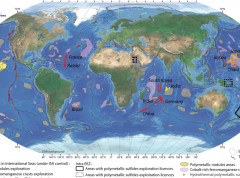
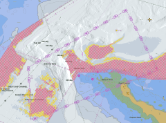
The BGR provides high resolution data for the Pacific and Indian Oceans
The German Federal Institute for Geosciences and Natural Resources (BGR) is participating in the IHO-led efforts to increase knowledge of the ocean and has shared high resolution depth data for the German contract areas for deep-sea exploration granted by the International Seabed Authority (ISA) in the Pacific and Indian Oceans. The BGR provided gridded data for 85.000 km² at a resolution of 120 x 120 meters.
World Oceans Day video
How can mapping the seabed contribute to initiatives like the Ocean Decade? The IHO produced a video for World Oceans Day which highlights some of the ways hydrography can contribute to increasing our knowledge of the ocean.
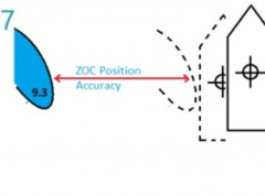
New guide on accuracy of depth information in Electronic Navigational Charts - ENCs
Data provided in electronic navigational charts can vary greatly in accuracy depending on when the sea survey to gather the data was carried out, the type of technology used, as well as the seafloor coverage.
How to Participate in World Hydrography Day
Celebrated on 21 June, World Hydrography Day is designed to raise awareness about hydrography and how it plays a role in improved knowledge of the seas and oceans.
Vital services continue around the world
Despite the covid-19 pandemic and many people across the world having to work from home, Hydrographic Offices around the globe can be proud of the work they are doing to continue to ensure safety at sea and other vital maritime services. Hydrographic Offices have had to adapt to new circumstances and are successfully ensuring that critical operations move forwards. Maritime Safety Information continues to be shared, NAVAREAs covered, and even the production and maintenance of digital nautical charts (ENCs) and relevant online marine data services is continuing despite constraints linked with the pandemic.
Worldwide ENC Database working group discusses the future of coverage
The Worldwide ENC Database working group (WEND) gathered last week to discuss the future of global ENC coverage, decisions which are key to support the safety of navigation, search and rescue activities, and mitigate the impacts of storms, marine pollution etc. The goal was to pave the way and be ready for when the new S-100 based digital products are implemented, and to try and coordinate initiatives.
Smart Navigation Moves Closer to Reality: Completion of Phase 1 of the S-100 Implementation
With the operational release of standards S-124 Navigational Warnings and S-128 Catalogue of Nautical Products, Phase 1 of S-100 Standards implementation has now been completed, marking a major step in the modernisation of navigation. Products and services using these specifications can be updated in near real-time, directly supporting the enhancement of navigational safety and facilitating on-board data management. Data services conforming to these standards are now ready for production and integration into navigation systems such as the S-100 ECDIS.
Empowering Women in Hydrography: A Transformative Three-Year Journey Towards Gender Equality
Like other disciplines within science, technology, engineering, and mathematics (STEM), hydrography exhibits a gender imbalance, particularly in advanced career stages. Currently, just over 10% of the 99 Member States of the International Hydrographic Organization (IHO) have a female National Hydrographer. And while women represent roughly half the population, only 24.8% of them occupy leadership positions with national hydrographic offices. In today’s competitive world, organizations need qualified employees to help them achieve their objectives. By not tapping into half of the available talent pool, they could be missing out. Acknowledging this disparity, the International Hydrographic Organization (IHO) and the Canadian Hydrographic Service collaboratively initiated a Canadian-funded, groundbreaking three-year project titled "Empowering Women in Hydrography," aimed at fostering gender equality in the field.

IHO welcomes 99th Member State
The Republic of Cabo Verde, an archipelago located 500km off the west coast of Africa in the Atlantic Ocean, has taken a stride towards improving its hydrographic capacity by becoming the 99th Member State of the International Hydrographic Organization (IHO). This strategic move positions Cabo Verde at the centre of international cooperation in the area of ocean affairs, unlocking a myriad of benefits for the nation and its rich marine environment.