Search results
There are 363 results for “sea” in All
SAIHC Letters
Read more
MACHC Letters
(English & Spanish only)
Read more
EAtHC18 (2024)
Read more
NSHC34 (2021)
Read more
HSSC11 (2019)
IHO Hydrographic Services and Standards Committee (HSSC) 11th HSSC meeting 6-9 May 2019, Cape Town, South Africa Last Update: 12 October 2020
Read more
Capacity Building Publications
Read more
News
IHO New Branding
Read more
Content
Acronyms Abbreviations Initialisms
Read more
News
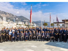
Member States Gather in Monaco for the IHO Council Meeting
Delegations representing Member States of the International Hydrographic Organization (IHO) convened in Monaco last week for the annual meeting of the Council. Participants from 30 Member States sitting on the Council, along with 13 Observers, discussed a wide range of topics including plans for a potential IHO Infrastructure Centre in the Republic of Korea, secure information exchange, and the ongoing transition to digital ocean data systems.
Read more