Search results
There are 362 results for “sea” in All
North Sea HC
Funded Opportunities for Training & Sea Survey Experience
As part of its ongoing commitment to strengthening hydrographic capacity worldwide, the IHO is pleased to share that several fully-funded opportunities for training and hands-on survey experience are currently open for applications, including a call to participate in a trans-Atlantic hydrographic survey.
Why CSB ?
Participating in the CSB Initiative benefits both those collecting the data and the communities of data users. These data contribute to increasing our knowledge, information which supports local regional and global initiatives in favour of the sustainable use of the oceans. They can also contribute to improved knowledge of seabed topography and better bathymetric maps or hydrographic charts in previously uncharted areas or areas lacking accurate data. This in turn can help avoid groundings and make navigation safer for all.
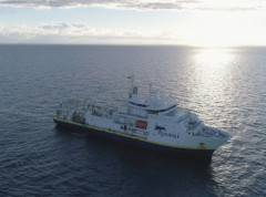
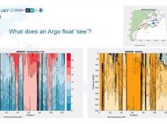
From ocean mapping to Argo floats: how are we learning about the changing ocean?
Better ocean data can be used to inform a variety of decisions from storm preparedness to seaweed farming. As part of the Monaco Ocean Week, the IHO hosted an event which provided an overview of some of the work being done to increase our knowledge of the ocean, from Prince Albert I of Monaco’s original idea of ocean mapping to the Argo programme, an exciting, global multidisciplinary project.
Baltic Sea HC
Importance of Hydrography
Definition of Hydrography Hydrography is the branch of applied sciences which deals with the measurement and description of the physical features of oceans, seas, coastal areas, lakes and rivers, as well as with the prediction of their change over time, for the primary purpose of safety of navigation and in support of all other marine activities, including economic development, security and defence, scientific research, and environmental protection. In addition to supporting safe and efficient navigation of ships, hydrography underpins almost every other activity associated with the sea, including: - resource exploitation - fishing, minerals,.. - environmental protection and management - maritime boundary delimitation - national marine spatial data infrastructures - recreational boating - maritime defence and security - tsunami flood and inundation modelling - coastal zone management - tourism - marine science
GEBCO Symposium 2026
The upcoming GEBCO Symposium, to be held in Cartagena, Colombia, will bring together the global ocean community to exchange knowledge, inspire collaboration, and advance our collective understanding of the seabed and the ocean environment.
MEETINGS AFTER 2024
List of the Meso American & Caribbean Sea Hydrographic Commission Meetings Note: To access the meeting page, you'll need an IHO Portal account. If you don't have one yet, don't worry! Creating an account is easy. Simply follow the instruction provided at the link here to set up your account and gain access to the meeting page. Click the IHO Portal to get started
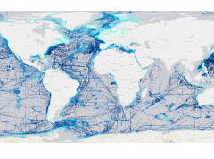
IHO Crowdsourced Bathymetry Initiative
The International Hydrographic Organization (IHO) has a long history of encouraging the collection of crowdsourced depth data to help improve humanity’s understanding of the shape and depth of the seafloor. For over a century, maps of the ocean floor were created from depth measurements collected by vessels as they journeyed across the oceans. These “passage soundings” enabled the creation of progressively more detailed seafloor maps and digital data grids. Recently, systematic surveys with specialized ships have contributed to greatly increasing available data. Unfortunately, despite the multitude of data that has been collected, to this day only 25% of the world’s ocean depths have been measured; the rest of the data used to compile seafloor maps are estimated depths.